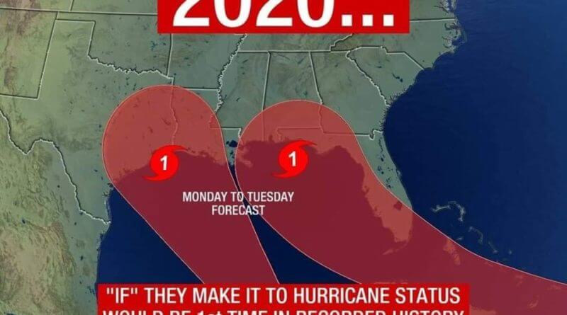
Potential for two hurricanes at same time in the Gulf
There is the potential for two hurricanes to be actice in the Gulf of Mexico at the same time, with a pair of tropical storms tracking very close to one another at this time according to the Mississippi Weather Network.
From MWN:
The new forecast from the NOAA NWS National Hurricane Center shows an adjusted cone further to the west, as expected based on earlier model runs. This cone now places the Mississippi Gulf Coast well within the real of possiblity for a hurricane landfall. Severe weather associated with this storm will be possible throughout east Mississippi as well if the current forecast holds.
We remind everyone that we are still at least 5 days out from potential landfall of #TropicalStormLaura so this forecast is very subject to changes until we get around 48 hours out. Mississippi Weather Network will continue to have the latest updates regarding the tropics and important information to keep you safe throughout the storm as we continue
Based on this mornings model runs, now tropical storm Laura looks to be taking a more westerly route than earlier forecast predictions which brings her dangerously close to a Mississippi gulf coast landfall.
We are still many days out from landfall and this forecast will remain very fluid until 48 hours or so out. If Laura does maintain this track it will mean a Florida landfall is not likely and it will place the storm over the boiling hot Gulf of Mexico for a longer period of time.
All other limiting factors remain very low, which means this storm could intensify further than the original forecast. We remind everyone to stay up to date with #TropicalStormLaura by turning on post notifications for Mississippi Weather Network as we continue our #TrackingTheTropics coverage
