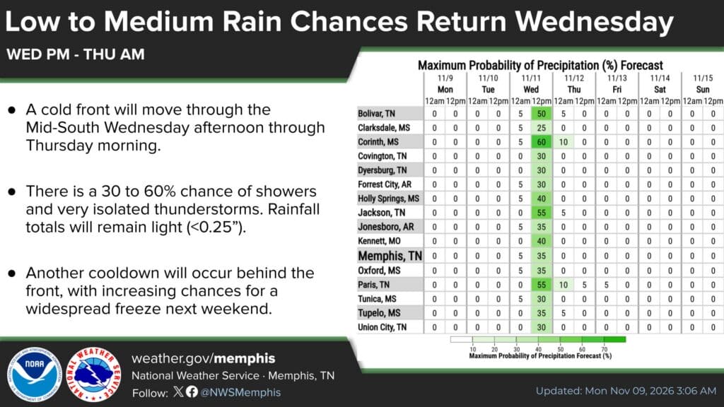
A mild start to the week will give way to the coldest air of the season so far. The National Weather Service in Memphis says a Corinth freeze is likely Friday night, with a forecast low near 28 degrees, after a cold front brings a few showers on Veterans Day. The same pattern covers Alcorn, Tishomingo, and Prentiss counties.
Temperatures will run near 70 degrees Monday through Wednesday before the front moves through Wednesday afternoon and evening. Behind it, highs will fall into the 50s and lows will drop below freezing for the first time this fall in many spots.
Veterans Day Forecast: Showers Mainly Wednesday Afternoon and Evening
The NWS forecast for Corinth calls for patchy morning fog Wednesday, Nov. 11, then a mostly sunny day with a high near 71 and a slight (20%) chance of showers. Rain chances rise to about 30% Wednesday night, mainly before midnight, when a few thunderstorms are also possible.
A forecaster graphic issued early Monday puts the peak rain chance in Corinth at 60% for the Wednesday afternoon-to-evening window, one of the highest in the Mid-South. Even so, the weather service expects rainfall totals to stay light, under a quarter of an inch, and under a tenth of an inch in Corinth itself.
That timing matters for anyone heading to Wednesday morning’s Corinth Veterans Day parade, which steps off at 10 a.m. Based on the current forecast, the morning should be mostly dry after any early fog lifts.
Corinth Freeze Forecast: Coldest Nights of the Fall
In its Monday morning forecast discussion, NWS Memphis said temperatures will “begin to plummet” behind Thursday’s front as colder air from the north moves in. Friday is expected to be brisk and breezy, and the weather service said the weekend could bring the region’s first areawide freeze of the season.
Here is the latest NWS point forecast for Corinth:
Monday night: Patchy fog, low around 41
Tuesday: Mostly sunny, high near 70; low around 45 with areas of fog
Wednesday (Veterans Day): High near 71, 20% chance of showers; 30% chance of showers and storms Wednesday night, low around 48
Thursday: Sunny and cooler, high near 59, northwest wind 10 to 15 mph; low around 35
Friday: Sunny, high near 50; low around 28 Friday night
Saturday: Sunny, high near 53; low around 30 Saturday night
Sunday: Sunny, high near 59
Protect People, Pets, Plants, and Pipes
A low in the upper 20s is cold enough to damage tender plants and to be dangerous for pets and livestock left outside without shelter. Ahead of Friday night, residents may want to:
Bring potted plants indoors or cover garden plants before sunset Friday.
Give outdoor pets a warm, dry shelter and make sure their water isn’t frozen.
Check on elderly neighbors and relatives.
Use space heaters safely, with plenty of clearance from anything that can burn, and never use grills or generators indoors.
Dry Weather Raises Fire Danger
Wednesday’s showers won’t do much to ease the dry conditions. The weather service said no appreciable rainfall is expected over the next seven days and that relative humidity could fall below 40% in parts of Northeast Mississippi on Monday and Tuesday. Forecasters warned that fire danger could increase by the end of the week as dry, breezy air settles in.
Outdoor burning is already restricted in one of our counties. The Tishomingo County burn ban remains in effect through Nov. 19. Elsewhere, anyone planning to burn leaves or brush should check local rules first and avoid burning on windy days.
Forecasts can change as the week goes on. For the latest, check weather.gov/memphis or a NOAA Weather Radio.
Jon R Myers is the executive editor of Alcorn County News and the founder of the Mississippi News Group, which he started in 2013 to cover communities across North Mississippi. He also founded the Mississippi Sports Group in 2006, which grew from a single community publication into a statewide network covering high school and college athletics. He reports on local government, public safety, schools and community life in Corinth and Alcorn County, working from public meetings, agency records and interviews with the people involved. Contact him at editor@alcornnewsms.com with news tips or corrections. For a correction, include the article link and supporting source material.
Stay connected
Your community. Wherever you are.
Follow Alcorn County News on Facebook for local news from Corinth and across Alcorn County.