Isaias Could Soak Northeast Mississippi With 3 Inches of Rain
The center of Tropical Storm Isaias could pass directly over or near our area this weekend. The National Weather Service in Memphis says the storm’s remnant low is currently forecast to track over far northeast Mississippi on Saturday afternoon. For Isaias Northeast Mississippi impacts, forecasters expect gusty winds and a soaking rain from early Saturday through Sunday evening, with the heaviest totals likely near the Tennessee River.
That puts Alcorn, Tishomingo and Prentiss counties close to the path of the storm’s leftovers. Forecasters stress that the exact track and strength are still uncertain several days out.
Where Isaias Is Now
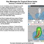
As of the National Hurricane Center’s 10 a.m. Wednesday advisory, Isaias was in the southern Gulf, about 540 miles south-southwest of the mouth of the Mississippi River. It had maximum sustained winds near 45 mph and was moving east-northeast at about 8 mph.
- The hurricane center expects rapid strengthening and says Isaias should become a hurricane by Thursday.
- A Hurricane Watch is in effect along the northern Gulf Coast from Bay St. Louis, Mississippi, to Indian Pass, Florida.
- Isaias is expected to turn northeast and then north Thursday and Friday and approach the northern Gulf Coast on Friday.
NWS Memphis says the latest forecasts put the most likely landfall near the Mississippi–Alabama border late Friday evening. The storm should weaken quickly once it moves inland.
Isaias Northeast Mississippi Rain and Wind Outlook
Because Isaias is expected to move quickly north after landfall, NWS Memphis says the fast pace should limit how much rain falls. Even so, forecasters project:
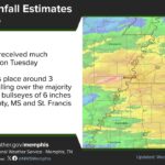
- Rainfall: an average of 1 to 3 inches east of the Mississippi River, with up to 4 inches possible locally near the Tennessee River. That includes the Pickwick Lake area of Tishomingo County.
- Wind: gusts could reach Wind Advisory levels east of the Mississippi River if the current track and strength hold.
- Timing: rain and wind should arrive early Saturday and last into Sunday evening. The remnant low should speed off through the Tennessee River Valley Saturday evening.
The NWS point forecast for Corinth calls for showers and thunderstorms likely Saturday, with east winds up to 20 mph and gusts as high as 35 mph. The chance of rain rises to 80% Saturday night, with southeast winds of 15 to 20 mph and gusts near 35 mph. More showers and storms are likely Sunday, with highs in the mid-70s. Gridded forecast data for Corinth shows roughly 2.5 to 3 inches of rain from Friday night through Sunday.
Fire Danger Peaks Before the Rain Arrives
Until the storm arrives, the area stays hot and dry. Highs should reach the upper 80s through Friday, 10 to 15 degrees above normal. NWS Memphis says afternoon humidity will drop to 25% to 35%. Wildland fire danger may peak on Friday, when winds increase ahead of Isaias.
Alcorn County’s emergency burn ban remains in effect through Oct. 12. All of Alcorn County was in severe (D2) drought on the late-September U.S. Drought Monitor map. Residents should avoid any outdoor burning, and should take care with equipment, cigarettes and anything else that could spark a fire in dry grass.
How to Prepare This Week
- Secure or bring in patio furniture, trash cans, decorations and other loose items before Saturday.
- Clear storm drains and gutters so heavy rain can drain from hard, dry ground.
- Charge phones and have flashlights ready in case gusty winds bring down limbs and power lines.
- Boaters and campers on Pickwick Lake and the Tennessee River should watch the forecast closely and plan to be off the water this weekend.
- Never drive through flooded roads. Turn around, don’t drown.
The forecast will likely change as Isaias gets closer to land. Check the National Weather Service in Memphis and the National Hurricane Center for updates, and keep a way to get weather warnings on your phone. Alcorn News MS will keep following the storm’s track and what it means for the Crossroads area.
Related: Alcorn County fire danger rises as heat nears 90
Source: National Hurricane Center; National Weather Service Memphis