Cold front could bring rain chances early in the week
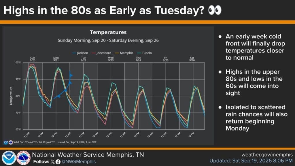
The National Weather Service Memphis said an early-week cold front is finally pushing record heat toward an end. Its forecast graphic showed isolated to scattered rain chances beginning Monday, with highs in the upper 80s and lows in the 60s in sight by Tuesday.
The National Weather Service Memphis forecast a cooler stretch for Corinth. A Sunday evening graphic showed highs of 97 Monday, 93 Tuesday, 87 Wednesday and 85 Thursday through Saturday, with 88 Sunday; overnight lows were shown at 73 Monday, 70 Tuesday, 66 Wednesday and 61 Thursday through Saturday, then 60 Sunday.
Afternoon storm risk brings a damaging-wind threat
The National Weather Service Memphis said a marginal risk for a severe thunderstorm or two exists this afternoon over portions of north Mississippi and West Tennessee near the Tennessee River. The graphic showed storms from 1 PM to 7 PM moving west to east, with damaging wind gusts up to 60 mph the main threat and no severe hail or tornadoes expected.
Jon R Myers is the executive editor of Alcorn County News and the founder of the Mississippi News Group, which he started in 2013 to cover communities across North Mississippi. He also founded the Mississippi Sports Group in 2006, which grew from a single community publication into a statewide network covering high school and college athletics. He reports on local government, public safety, schools and community life in Corinth and Alcorn County, working from public meetings, agency records and interviews with the people involved. Contact him at editor@alcornnewsms.com with news tips or corrections. For a correction, include the article link and supporting source material.
Stay connected
Your community. Wherever you are.
Follow Alcorn County News on Facebook for local news from Corinth and across Alcorn County.