North Mississippi weather shifts from rain to fire risk and a cooler Corinth weekend
Wednesday rain chances mainly along and north of I-40
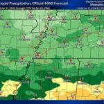
The National Weather Service in Memphis says a front will stall north of the region Wednesday, bringing shower and thunderstorm chances mainly along and north of I-40. The forecast graphic is titled "Much Needed Rainfall" and covers Wednesday and Wednesday night.
The graphic calls for 0.25 to 1.0 inches of rain in that corridor and warns that slow-moving storms could produce locally heavier amounts and an isolated nuisance flooding threat.
Source: US National Weather Service Memphis Tennessee.
Friday fire-weather risk stays elevated
The National Weather Service in Memphis posted an updated Friday fire weather outlook Tuesday night. It says the 40% risk area was trimmed back on the northern side because the cold front should pass earlier Friday morning. The outlook still shows a 40-69% fire weather potential, with humidity of 30-40% and winds of 10-20 mph with gusts up to 30 mph, and it tells people to avoid equipment that creates sparks, obey local burn bans and permit rules, and dispose of cigarettes and matches properly.
Source: US National Weather Service Memphis Tennessee.
Corinth cools after the front arrives Friday
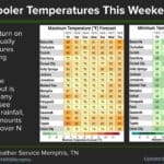
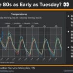
The National Weather Service in Memphis says cooler temperatures arrive Friday in Corinth, with the coolest period expected Saturday afternoon into Sunday morning. Its graphic shows Corinth highs of 91 Thursday, 71 Friday, 66 Saturday, 70 Sunday and 71 Monday, along with lows of 66 Thursday night, 52 Friday night, 46 Saturday night, 43 Sunday night and 50 Monday night. It says temperatures will gradually warm into next week.
Source: US National Weather Service Memphis Tennessee.