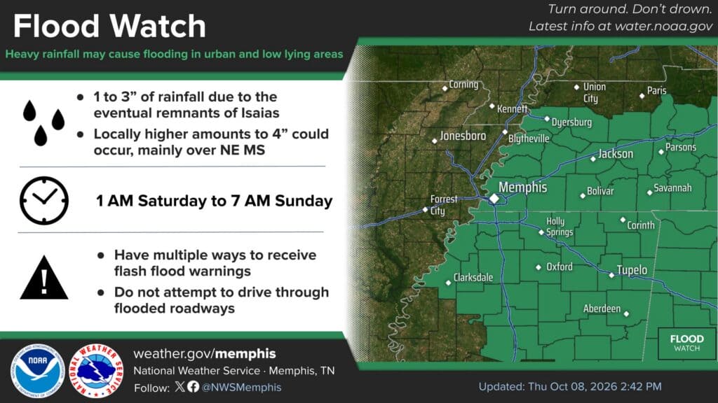
The National Weather Service in Memphis has issued a Flood Watch for Alcorn County, Prentiss County and Tishomingo County as the remnants of Hurricane Isaias move inland this weekend. The watch runs from 1 a.m. Saturday until 7 a.m. Sunday and covers most of North Mississippi and West Tennessee. The rain could be heavy enough to flood creeks, streams and low-lying roads across Corinth, Booneville, Iuka and the surrounding communities.
The watch was issued around midday Thursday, Oct. 8. Forecasters say 1 to 3 inches of rain are likely, with locally higher amounts up to 4 inches. The heaviest totals are expected over far Northeast Mississippi and near the Tennessee River.
What the Flood Watch for Alcorn County Means
A Flood Watch means conditions are favorable for flooding, not that flooding is already happening. The weather service says runoff from heavy rain “may result in flooding of rivers, creeks, streams, and other low-lying and flood-prone locations.” If flooding develops or is imminent, the watch may be upgraded to a Flood Warning or Flash Flood Warning for specific areas.
The region has been in a deep drought, which makes the setup unusual. In Thursday’s forecast discussion, NWS Memphis noted that much of the Mid-South is in severe (D2) to extreme (D3) drought with very dry soils. Hard, dry ground can shed a sudden downpour quickly instead of soaking it up, especially in ditches, culverts and urban areas.
Weekend Timeline for Corinth and the Crossroads
Friday: Sunny and very warm, with a high near 88 in Corinth. Rain chances begin late Friday night, mainly after 5 a.m. Saturday.
Saturday: Rain, then showers and thunderstorms, some with heavy rain. A rain chance of 100 percent, with 1 to 2 inches possible during the day alone. East-northeast winds of 5 to 25 mph with gusts as high as 40 mph. Temperatures will hold in the upper 60s to low 70s.
Saturday night: More showers and storms, with gusts up to 35 mph.
Sunday: Rain is expected to move out by around midday, and dry, warm weather returns early next week.
Forecasters said a Wind Advisory will likely be needed for parts of the Mid-South on Saturday. They are not expecting severe weather with Isaias’s current track, though brief spin-up tornadoes can’t be ruled out if the remnants shift farther west. As of the 1 p.m. advisory Thursday, Isaias was a hurricane in the Gulf with maximum sustained winds of 85 mph, moving east-northeast toward the northern Gulf Coast.
Some forecast models still keep the Mid-South drier on the west side of the storm, so rainfall totals could change. Check for updated forecasts through Friday.
How to Prepare
Have more than one way to receive warnings, such as a weather radio, phone alerts and local media.
Never drive through flooded roadways. Turn around, don’t drown.
Clear leaves and debris from gutters and storm drains before Saturday.
Secure loose outdoor items, including Halloween decorations, ahead of the gusty winds.
Charge phones and keep flashlights handy in case of power outages.
The Alcorn County Electric Power Association posted Thursday that it is preparing for the incoming weather and urged members to get ready as well and watch its social media for updates.
The rain should ease the fire danger that has led to burn bans and recent wildfires across the area. The Alcorn County burn ban is set to expire Oct. 12.
Jon R Myers is the executive editor of Alcorn County News and the founder of the Mississippi News Group, which he started in 2013 to cover communities across North Mississippi. He also founded the Mississippi Sports Group in 2006, which grew from a single community publication into a statewide network covering high school and college athletics. He reports on local government, public safety, schools and community life in Corinth and Alcorn County, working from public meetings, agency records and interviews with the people involved. Contact him at editor@alcornnewsms.com with news tips or corrections. For a correction, include the article link and supporting source material.
Stay connected
Your community. Wherever you are.
Follow Alcorn County News on Facebook for local news from Corinth and across Alcorn County.